The Clock Runs Through the Massachusetts Bay Approach
The Plymouth start on 11 May 2008 initiated a continuous timer that ran without suspension across the North Atlantic. Arriving at the Massachusetts Bay entrance introduces a distinct timing problem for a solo skipper. Elapsed time keeps running in the closing miles. The ocean-gap/bay-tax breakdown separates time earned before Massachusetts Bay from time surrendered while crossing its flood, slack, and ebb windows.
Boston-area tides are predominantly semidiurnal. Successive high waters average roughly 12 hours and 25 minutes apart. Each broad rising or falling phase occupies approximately 5 hours and 45 minutes to 6 hours and 40 minutes. A mistimed arrival forces a boat to sail against a massive volume of moving water. The stake is the clock itself, as the bay taxes every remaining mile sailed in a foul stream.
Skippers must assess the final approach by comparing their projected arrival at the bay entrance with the next favorable stream. They then recalculate the elapsed-time cost for pressing immediately versus changing speed offshore. Preserving an ocean-earned lead requires treating the coastal water as a separate navigational regime.
Reversing Coastal Streams in the Final Miles
The bay operates independently of the weather systems crossed earlier in the Atlantic, functioning as a reversing coastal body. Flood generally sets into Boston Harbor. Ebb sets seaward. Current turns vary by station across the approach and rarely coincide perfectly with the published times of high or low water.
Harbor constriction and the wider bay behave as a complex hydraulic system. Approach water helps or hinders progress long before the finish line appears on the horizon. The historical record confirms the bay tax — archival finish timestamps matched to current stations demonstrate as much.
For the 23-29 May 2008 arrival period, accurate analysis requires predictions generated specifically for those calendar dates. Timestamps must be standardized to one zone before assigning a tidal phase. Classifying each archived arrival by the predicted current phase on its actual approach track provides a clearer picture of the final standings than merely referencing the tide height at Boston.
Navigating the Constricted Fairways
Boats closing from the east meet shipping channels, headlands, and a narrowing set of options. The open-ocean freedom to choose a rhumb line disappears. The last fairway is coastal water governed by local set.
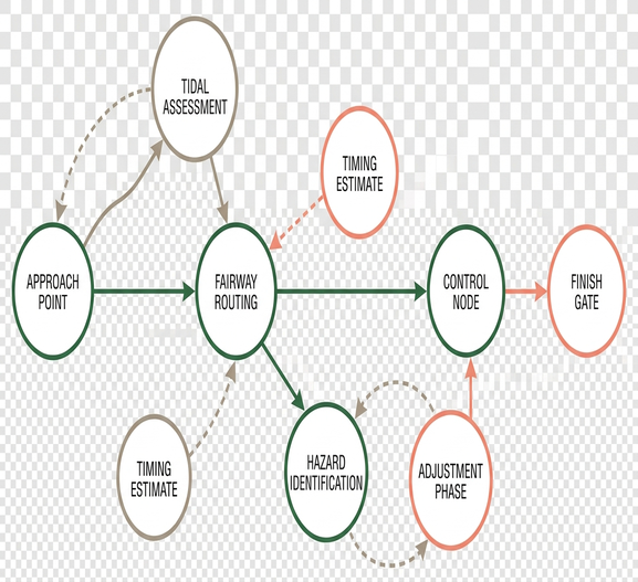
A current on the bow reduces speed over ground directly. A cross-current adds set, requiring a compensating heading that alters the apparent-wind angle and the attainable velocity made good (VMG). These hydrodynamic penalties compound just when solo crews are shortest of rest.
Projecting the boat from open bay water through its intended traffic-safe approach requires segmenting the route wherever the heading or channel geometry changes. For each segment, navigators combine through-water speed with the predicted current vector to estimate speed over ground. This continuous recalculation dictates whether a skipper pushes hard through the night or throttles back to await a favorable turn.
Reconstructing the May 2008 Finish Records
The useful archive interval runs from the leading Boston arrival on 23 May 2008 through the later Class 40 arrivals near 29 May 2008. Reconstructing these arrival windows involves ordering the finish records in Coordinated Universal Time (UTC), calculating a backward ETA band for each boat, and overlaying the historical current phase.
Finish-time records from the 2008 Artemis Transat show that boats reaching the approaches on a making flood closed faster over the ground than boats meeting the ebb. The comparison evaluates window against window. Two similar campaigns can separate significantly in the bay while their ocean gap stays small.
This reconstruction identifies tidal exposure across the 23-29 May 2008 approach boundary, though it cannot isolate the full time cost without synchronized position reports, through-water speed, and local wind observations for each boat. Retaining wind and route evidence prevents attributing every separation solely to the tide. The analysis requires at least three fields for every comparison: recorded finish time, estimated time entering the final 20-60 nautical miles, and predicted current phase along that specific approach.
Speed Differentials and Tidal Exposure
The portal records both IMOCA 60 and Class 40 yachts at Boston. The same bay treats different closing speeds as entirely different tactical problems. Building separate ETA bands for IMOCA 60 and Class 40 boats from their own recent speed traces reveals how speed dictates tidal strategy.
A boat closing the final 60 nautical miles at 12 knots has a still-water passage time of 5 hours. At 8 knots, the same distance requires 7 hours and 30 minutes. That slower pace spans a materially larger part of one tidal phase.
Faster IMOCA 60s maintain the scope to move their arrival between adjacent current phases. During the last 6-12 hours offshore, an IMOCA skipper can test whether a deliberate speed adjustment will shift bay entry into the next favorable phase. If the required delay exceeds the boat's practical timing margin, they accept the inherited stream and minimize exposure through careful routing.
Slower Class 40s more often inherit whatever stream is running. A Class 40 held in foul current spends a larger share of its remaining race paying the tax. They remain committed across most of a flood-to-ebb transition, lacking the raw speed to punch through a closing window before the tide turns against them.
Calculating the Offshore Timing Margin
Matching the predicted Boston Harbor stream to the remaining distance and the boat’s closing speed determines whether arriving immediately is cheaper than arriving later. Holding offshore for a fair flood frequently beats sailing a foul ebb all the way in, even if the GPS finish line looks tantalizingly close.
The analytical process begins by converting the official historical current predictions and the race clock to the same time standard. Navigators then calculate best-case, expected, and reduced-speed ETAs based on the remaining distance and recent boat speed. A practical ETA bracket uses three speed cases drawn from the preceding 3-6 hours rather than relying on a single instantaneous GPS value.
Each ETA is assigned to a flood, slack, or ebb phase to estimate the resulting speed-over-ground change. Skippers update this choice after every new position report. The calculation resets when the remaining distance changes by 10-20 nautical miles or after 1-3 hours, whichever occurs first. All times remain in UTC until the phase comparison is complete.
The analysis ruled out high-water time as a substitute for the actual current phase. Skippers must use official NOAA Boston tide predictions as the definitive clock for the bay, overlaying the boat’s polar data to make informed routing decisions.
The Coastal Conclusion to an Ocean Crossing
The Artemis Transat of 2008 was a Plymouth-to-Boston ocean race whose final miles ran in water that had never been part of the North Atlantic crossing. The decisive coastal analysis concerns approximately the final 20-60 nautical miles. Here, local current alters speed over ground entirely independent of the deep-water weather systems.
Treating the race as two connected timing regimes provides the most accurate historical framework. Ocean passage from Plymouth establishes the baseline ranking. The reversing coastal stream governing the Boston approach determines the final elapsed time. Archival interpretation closes only after reconciling the finish timestamp with the specific bay phase encountered during those final miles.
A Class 40 closing the final 60 nautical miles at 8 knots requires 7 hours and 30 minutes of still-water passage time, guaranteeing exposure to a reversing tidal phase that lasts at most 6 hours and 40 minutes.